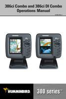

0
Owner's of the Humminbird Marine GPS System Di Combo gave it a score of 0 out of 5. Here's how the scores stacked up:

163
GPS & Navigation Terms:
Acquisition Time The length of time that a GPS receiver typically takes to determine a
position from at least three satellites. Humminbird® GPS receivers provide very fast
acquisition times (under one minute), permitting users to get out on the water faster.
Altitude The heightmeasurement above sea level.Altitude isa measurementthat can be
provided by GPS.
Bearing (BRG) The direction to a destination waypoint measured in degrees from North
(i.e. 321°, where 000° is North, 090° East, 180° is South, 270° is West).
Chartplotter A navigation device that shows Present Position on a Map, along with
Tracks, Waypoints, and Routes. All Chartplotters are also considered Trackplotters.
Cold Start The procedure that a GPS receiver must perform when it does not have
historicalinformationregardingitscurrentlocation.Thisproceduretypicallylastsforseveral
minutes, and may be experienced uponfirst power up ofthe receiver, or if the receiver has
been moved a great distance.
Course Over Ground (COG) The current direction the boat is traveling measured in
degreesfromNorth(i.e. 321°,where000° isNorth,090°East, 180°is South,270°isWest).
When the Course Over Ground is equal to Bearing, the boat is said to be “On Course” and
will arrive at the destination in the most efficient manner. COG is often confused with
Heading. See
Heading.
Cross Track Error (XTE) The straight-line distance of the boat from the intended Track.
XTE measures how far the boat is off course and also triggers the Off Course Alarm. See
Track.
Differential GPS (DGPS) A system used to improve the position accuracy of the
Department of Defense GPS through the use of secondary “correction signals” broadcast
from ground stations around the coastal United States and on some inland waterways.
These correction signals are provided by the USCGand received by an auxiliaryDifferential
BeaconReceiver (DBR) that connects to the GPS receiver. The advent of WAAShas largely
negated the need for the added expense of a DBR in the United States.
Distance To Go The straight-line distance between Present Position and the Destination
Waypoint. DTG and SOG (Speed Over Ground) are used to calculate Time To Go. See
Time
to Go and Speed Over Ground.
Glossary -GPS & Navigation Terms


Find Your Products By Category
- Communications
- Photography
- Portable Media
- Home Audio
- Kitchen Appliance
- Computer Equipment
- TV and Video
- Cell Phone
- Household Appliance
- Video Game
- Laundry Appliance
- Musical Instruments & Equipment
- Power Tools
- Automotive
- Car Audio and Video
- Outdoor Cooking
- Marine Equipment
- Lawn and Garden
- Personal Care
- Fitness & Sports
- Baby
Please Login
