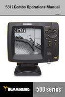

0
Owner's of the Humminbird Marine GPS System Marine GPS gave it a score of 0 out of 5. Here's how the scores stacked up:


24
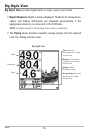
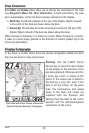
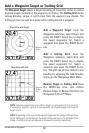
Routes link two or more waypoints together to create a path for navigation and
are used in trip planning. You can link individual waypoints together by using the
GOTO key. A route represents your intended navigation and shows the shortest
path from each waypoint to the next. As you travel a route, staying on the route
line is the most efficient way to get to your destination, although you should
always look out for obstacles not shown on the chart. Your 500 Series™
Fishfinder can store up to 50 routes that can each contain up to 50 waypoints.
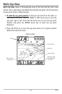
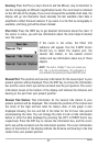
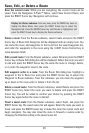
Tracks consist of detailed position history and are displayed as a breadcrumb
trail of trackpoints. The Current Track shows the position history since the unit
was powered up (maximum of 20,000 trackpoints displayed). You can clear the
Current Track or save it at any time. Your 500 Series™ Fishfinder can store up
to 50 saved tracks, each containing 20,000 trackpoints. The current track
represents your actual path so far.
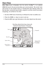
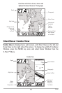
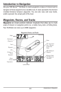
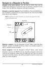
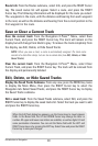
NOTE: When two or more waypoints overlap, or are displayed close together on a
chart view, the screen will automatically declutter—waypoint names will shorten
and the waypoint icons will change into small gray icons.
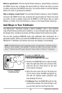
To view a Decluttered Waypoint at full size, use the 4-WAY Cursor Control key to
move the cursor onto a decluttered waypoint icon. When the cursor snaps onto the
icon, the full-size waypoint name and icon will be displayed. You can also press the
ZOOM+ key until you can see the individual waypoints on the screen. See
Navigation Menu Tab: Waypoint Decluttering to turn off this feature.
Introduction to Navigation


Find Your Products By Category
- Communications
- Photography
- Portable Media
- Home Audio
- Kitchen Appliance
- Computer Equipment
- TV and Video
- Cell Phone
- Household Appliance
- Video Game
- Laundry Appliance
- Musical Instruments & Equipment
- Power Tools
- Automotive
- Car Audio and Video
- Outdoor Cooking
- Marine Equipment
- Lawn and Garden
- Personal Care
- Fitness & Sports
- Baby
Please Login
