

0
Owner's of the Humminbird Marine GPS System 4086301 gave it a score of 0 out of 5. Here's how the scores stacked up:
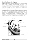
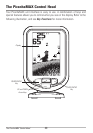

How GPS Works
If your PiranhaMAX model includes GPS (Global Positioning System), it will use
GPS and sonar to determine your current track, display it on a grid, and provide
detailed underwater information.
GPS uses a constellation of satellites that
continually send radio signals to the earth. The
GPS receiver on your boat receives signals from
satellites that are visible to it. Based on time
differences between each received signal, the
GPS receiver determines its distance to each
satellite. With distances known, the GPS receiver
mathematically triangulates its own position.
With 5 updates per second, the GPS receiver then
calculates its velocity and bearing.
GPS was originally intended for military use; however, civilians may also take
advantage of its highly accurate position capabilities, typically within +/- 4.5
meters, depending on conditions. This means that 95% of the time, the GPS
receiver will read a location within +/- 4.5 meters of your actual position. Your
GPS Receiver also uses information from WAAS (the Wide Area Augmentation
System), EGNOS (the European Geostationary Navigation Overlay Service), and
MSAS (the MTSAT Satellite Augmentation System) satellites if they are
available in your area.
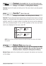
PiranhaMAX models that include GPS currently support the following GPS
functionality:
• View current track (breadcrumb trail)
• View precision speed and heading
• Save waypoints. Your Fishfinder can store over 500 waypoints.
See Track View for more information.
39
How GPS Works


Find Your Products By Category
- Communications
- Photography
- Portable Media
- Home Audio
- Kitchen Appliance
- Computer Equipment
- TV and Video
- Cell Phone
- Household Appliance
- Video Game
- Laundry Appliance
- Musical Instruments & Equipment
- Power Tools
- Automotive
- Car Audio and Video
- Outdoor Cooking
- Marine Equipment
- Lawn and Garden
- Personal Care
- Fitness & Sports
- Baby
Please Login
