
0
Owner's of the Clarion GPS Receiver NP401 gave it a score of 0 out of 5. Here's how the scores stacked up:

English
Owner’s
Manual
48 NP401
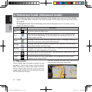
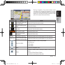
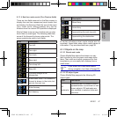
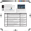
Type Description
Elevation
model
Hills and mountains are shown in the
background of the 3D map view, and
illustrated by color on the 2D map.
Elevated
roads
Complex intersections and vertically
isolated roads (such as overpasses
or bridges) are displayed in 3D.
3D
buildings
Full 3D city building data that
represents actual building size and
position on the map. Building data
is limited to the city centers of major
cities in the US and Europe.
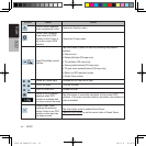
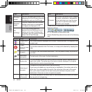
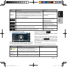
Type Description
3D terrain
3D terrain map data shows changes
in terrain, elevations or depressions
in the land when you view the map,
and use it to plot the route map in
3D when you navigate.
To fine-tune 3D visualization on the map, tap the
following buttons:
, , , .
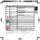
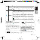
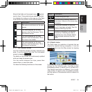
6.1.2.3Elementsoftheactiveroute
Clarion Mobile Map shows the route in the following
way:
Symbol Name Description
Current GPS
position
Your current position displayed on the map. If roads are near, it is aligned to the
nearest road.
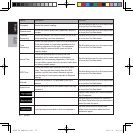
Cursor
(selected map
location)
The location selected in the Find menu, or a map point selected by tapping the
map.
Via point
A via point is an intermediate destination. You can place as many via points as
you want.
Destination
(end point)
The last point of the route, the final destination.
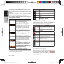
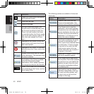
Route color
The route always stands out with its color on the map, both in daytime and in
night color mode. The active leg of the route is always displayed in a brighter
shade than the inactive (upcoming) legs.
Active leg of
the route
The section of the route on which you are driving.
If you have not added any via points (only a destination), the entire route is the
active leg. If you have added via points, the active leg is the part of the route
from your current location to the next route point (the next via point, or the
destination if there are no more via points to reach).
Inactive legs
of the route
The future sections of the route; each of them becomes active when you reach
the via point at its beginning.
NP401 OM_100920_EN.indd 48 2011-1-6 16:10:58


Find Your Products By Category
- Communications
- Photography
- Portable Media
- Home Audio
- Kitchen Appliance
- Computer Equipment
- TV and Video
- Cell Phone
- Household Appliance
- Video Game
- Laundry Appliance
- Musical Instruments & Equipment
- Power Tools
- Automotive
- Car Audio and Video
- Outdoor Cooking
- Marine Equipment
- Lawn and Garden
- Personal Care
- Fitness & Sports
- Baby
Please Login
