
0
Owner's of the Clarion GPS Receiver NP401 gave it a score of 0 out of 5. Here's how the scores stacked up:
English
Owner’s
Manual
20 NP401
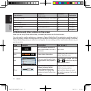
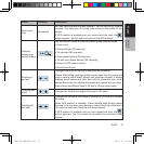
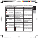
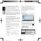
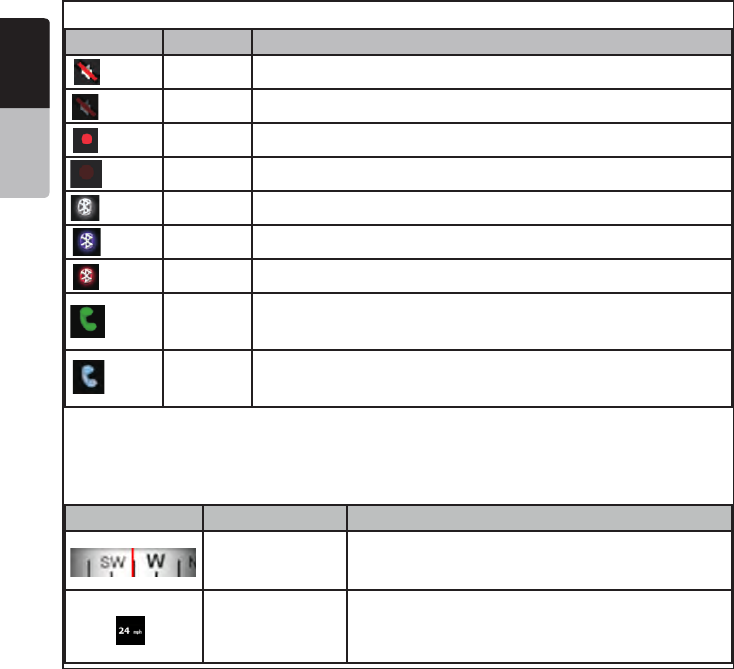
The following symbols appear in the Indicator strip:
Icon Color Description
Icon Description
The sound output of Clarion Mobile Map
ismuted.
The sound output of Clarion Mobile Map
isenabled.
Clarion Mobile Map records a Track log
whenGPSpositionisavailable.
Tracklogrecordingisdisabled.
TheBluetoothradioisswitchedoff.
The Blueto oth radio is turned on but no,
telephone isconnected.
Thereisanerrorinthe Bluetoothconnection.
Clarion Mobile Map is connected to a telephone
asahandsfreesetvia Bluetooth.
A phone call is in progress over the Bluetooth
color
White
White
Redblinking
Red
Red
Gray
Purple
Green
Blue
White Thesound output of Clarion Mobile Map is muted.
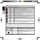
Icon Description
The sound output of Clarion Mobile Map
ismuted.
The sound output of Clarion Mobile Map
isenabled.
Clarion Mobile Map records a Track log
whenGPSpositionis available.
Track logrecordingis disabled.
TheBluetoothradiois switchedoff.
The Bluetooth radio is turned on but no,
telephone isconnected.
Thereisanerrorin theBluetoothconnection .
Clarion Mobile Map isconnected to atelephone
asa handsfree setvia Bluetooth.
A phone call is in progress over the Bluetooth
color
White
White
Redblinking
Red
Red
Gray
Purple
Green
Blue
White Thesound output of Clarion Mobile Map is enabled.
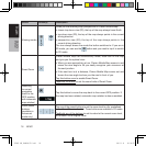
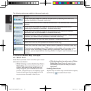
Icon Description
The sound output of Clarion Mobile Map
is muted.
The sound output of Clarion Mobile Map
is enabled.
Clarion Mobile Map records a Track log
whenGPS positionis available.
Track log recordingis disabled.
TheBluetoothradio is switchedoff.
The Bluetooth radio is turned on but no,
telephone is connected.
Thereis anerrorin the Bluetoothconnection.
Clarion Mobile Map isconnected toa telephone
asa handsfreeset via Bluetooth.
A phone call is in progress over the Bluetooth
color
White
White
Redblinking
Red
Red
Gray
Purple
Green
Blue
Red blinking Clarion Mobile Map recordsaTrack logwhen GPS position is available.
Icon Description
The sound output of Clarion Mobile Map
is muted.
The sound output of Clarion Mobile Map
is enabled.
Clarion Mobile Map records a Track log
when GPS position is available.
Track log recording isdisabled.
The Bluetooth radio is switched off.
The Bluetooth radio is turned on but no,
telephone is connected.
There is an error in the Bluetooth connection.
Clarion Mobile Map is connected to a telephone
as a handsfree set via Bluetooth.
A phone call is in progress over the B luetooth
color
White
White
Redblinking
Red
Red
Gray
Purple
Green
Blue
Red Tracklog recording isdisabled.
Icon Description
The sound output of Clarion Mobile Map
is muted.
The sound output of Clarion Mobile Map
is enabled.
Clarion Mobile Map records a Track log
when GPS position is available.
Track log recording is disabled.
The Bluetooth radio is switched off.
The Bluetooth radio is turned on but no,
telephone is connected.
There is an error in the Bluetooth connection.
Clarion Mobile Map is connected to a telephone
as ahandsfree set via Bluetooth.
A phone call is in progress ove r the Bluetooth
color
White
White
Redblinking
Red
Red
Gray
Purple
Green
Blue
Gray TheBluetooth radio is switched off.
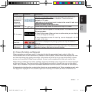
Icon Description
The sound output of Clarion Mobile Map
is muted.
The sound output of Clarion Mobile Map
is enabled.
Clarion Mobile Map records a Track log
when GPS position is available.
Track log recording is disabled.
The Bluetooth radio is switched off.
The Bluetooth radio is turned on but no,
telephone is connected.
There isan error in the Bluetooth connection.
Clarion Mobile Map is connected to a telephone
as a handsfree set via Bluetooth.
A phone call is in progress over the Bluetooth
color
White
White
Redblinking
Red
Red
Gray
Purple
Green
Blue
Purple TheBluetooth radio is turnedon but no telephone isconnected.
Icon Description
The sound output of Clarion Mobile Map
is muted.
The sound output of Clarion Mobile Map
is enabled.
Clarion Mobile Map records a Track log
when GPS position is available.
Track log recording is disabled.
The Bluetoothradio is switched off.
The Bluetooth radio is turned on but no,
telephone is connected.
There is an error inthe Bluetooth connection.
Clarion Mobile Map is connected to a telephone
as ahandsfree set via Bluetooth.
A phone call is in progress over the Bluetooth
color
White
White
Redblinking
Red
Red
Gray
Purple
Green
Blue
Red There isan error in theBluetooth connection.
Icon Description
The sound output of Clarion Mobile Map
is muted.
The sound output of Clarion Mobile Map
is enabled.
Clarion Mobile Map records a Track log
when GPS position is available.
Track log recording is disabled.
The Bluetooth radio is switched off.
The Bluetooth radio is turned on but no,
telephone is connected.
There is an error in the Bluetooth connection.
Clarion Mobile Map is connected to a telephone
as a handsfree set via Bluetooth.
A phone call is in progress over the Bluetooth
color
White
White
Redblinking
Red
Red
Gray
Purple
Green
Blue
Green
Clarion Mobile Map is connected to a telephone as a handsfree set via
Bluetooth
Icon Description
The sound output of Clarion Mobile Map
is muted.
The sound output of Clarion Mobile Map
is enabled.
Clarion Mobile Map records a Track log
when GPS position is available.
Track log recording is disabled.
The Bluetooth radio is switched off.
The Bluetooth radio is turned on but no,
telephone is connected.
There is an error in the Bluetooth connection.
Clarion Mobile Map is connected to a telephone
as a handsfree set via Bluetooth.
A phone call is in progress over the Bl uetooth
color
White
White
Redblinking
Red
Red
Gray
Purple
Green
Blue
Blue A phone call is in progress over theBluetooth connection.
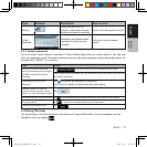
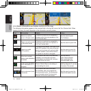
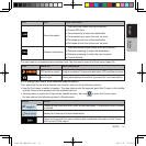
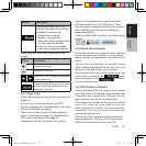
The following information can be seen in the three data fields shown on the map screen. Tap this area to
open the Trip Information screen where you can select which values to be shown in these three fields.
When there is no active route, these fields show the following information: current speed, compass and the
current time of day.
Icon Type More information
Compass
Shows the direction of your heading both when the map
is automatically rotated (3D) and when the map is always
facing North (2D).
Speed information
There are speed values that can be shown:
•Currentspeed
•Speedlimitonthecurrentroad
NP401 OM_100920_EN.indd 20 2011-1-6 16:10:53


Find Your Products By Category
- Communications
- Photography
- Portable Media
- Home Audio
- Kitchen Appliance
- Computer Equipment
- TV and Video
- Cell Phone
- Household Appliance
- Video Game
- Laundry Appliance
- Musical Instruments & Equipment
- Power Tools
- Automotive
- Car Audio and Video
- Outdoor Cooking
- Marine Equipment
- Lawn and Garden
- Personal Care
- Fitness & Sports
- Baby
Please Login
